Check out our Drone Project here!

Thursday, October 31, 2013

Weather Balloon

The GHS EAST program will be launching a camera, GPS, and instruments to collect data into the outer reaches of the atmosphere. In order to do so we will be using a 20ft weather balloon. This balloon weighs 600g and will hold 50-100 cubic feet of helium. When we launch it at earths surface it will have a diameter of about 6ft. As it rises, the lower air pressure allows the helium inside the balloon to expand stretching the balloon to around 20ft. At around 30,000 meters (20 miles) the balloon will burst from the pressure and the payload will fall back to earth.

20 ft weather balloon
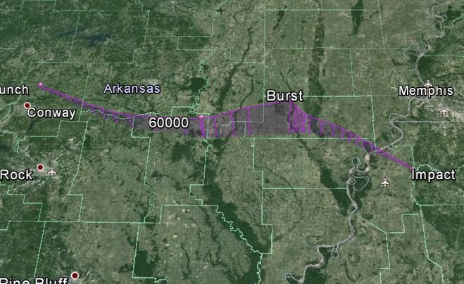
We expect the flight to take around 2 hours and recent trajectory forecasts predict that the landing will be somewhere between Jonesboro, AR and Memphis,TN.

Our anticipated launch date is November 15 2013.

Tuesday, October 29, 2013

High Altitude Camera Test

After getting our helium canister I noticed that it was almost empty. Instead of letting all that good helium go to waste I decided to do a few test with it. I filled 4 large trash bags with the remaining helium and tied about 300 Ft of string to the trash bags. Then with a large amount of tape I secured the Gopro to the base of the trashbags. Then I took it to the back yard and allowed the camera to rise.


Photo from about 200 ft up


When I began to pull the balloon back in the string fell and became caught in a tree. Not wanting to lose the camera for good I called upon my grandfathers trusty pellet gun to breach the trash bags and safely return it to the ground.


Balloon 35 ft up with string caught in tree

Flight Trajectory Prediction

Using a program designed to predict the flight of a balloon we have been recording data in order to find an average landing zone. These are the recorded flight from the last few days


Path of the Weather Balloon (Coordinates)
Predicted coordinates of Day 4 flight


Day 1

Day 2

Day 3
Day 4


After finding the average coordinates of the landing point we looked them up on Google maps and...

It landed in the Mississippi River

Monday, October 28, 2013

Equipment Inventory and Weigh-in


Calculating Total Weight of the Balloon Payload.  Contents include a GoPro Hero3 Camera, a SPOT GPS,  Parachute and a sturdy Styrofoam cooler retrofitted to hold the camera and GPS.  Total Payload is coming in at around 3.625 lbs.   


The SPOT GPS is used primarily as a safety tracking device for hikers or outdoors men.  It has an emergency signal that can be activated to notify friends or authorities if trouble arises.  It has a check-in feature that sends a regular signal that can be tracked online or with an app. We will use this tracking feature to follow our balloon in flight and retrieve it when it lands.    


The GoPro Hero3 Camera is a tiny high-resolution video and still camera that shoots amazing quality footage.  It is used mainly by outdoor adventurers and athletes.  It has a waterproof, shockproof casing and comes with many adjustable mounts.  It has the capability to take hi-res video and still shots at the same time and record them on a 64Gb Micro SD card.      


At an altitude of  60,000-120,000 feet (18-37 km) the balloon will explode from the increased internal pressure and the parachute will deploy as the payload falls back to earth.   


We are constructing a case from a sturdy, lightweight Styrofoam cooler.  The case needs to protect the equipment from high winds and low temperatures at higher altitudes as well as potential hard landings or water landings.  

Sunday, October 27, 2013

GHS EAST Space Balloon


This is the chronicles of a Greenbrier High School (Greenbrier, Arkansas) EAST Project to launch a weather balloon into near space. We will document the trip with video and photos using a GoPro Hero3 camera and track its movement online with a SPOT GPS.  We will gather Altitude, and Temperature data using an Arduino Uno with a barometer component.  Projected Launch Date is November 15, 2013.